


Cambodia Geography
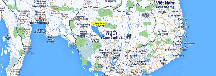
Cambodia has a total landmass of slightly more than 180,000 square kilometers. It is situated in the centre of the Southeast-Asien peninsula. Cambodia's 2,572 km border is split among Vietnam (1,228 km) to the east, Thailand (803 km) to the west and northwest, and Laos (541 km) to the northeast. Cambodia has about 15 million inhabitants, 90% of them are Khmer, meaning Khmer is their native language.
20 percent of the land is used for agriculture, mainly wet rice cultivation in the more densely populated river plains in the core of Cambodia. 2800 square kilometres are irrigated. Altogether, the central plains of Cambodia cover three quarters of the country. They are dominated by the Mekong River, crossing the country's eastern half from north to southeast, and two major tributaries, viz. the Tonle Sap from the west and the Bassac river to the south. The Mekong river originates in Tibet, before entering Cambodia it flows along the Chinese border of Myanmar, through Laos, along its border with Thailand. The Tonle Sap flows into the Mekong at to Phnom Penh. Nearly at the same spot the delta distributary Bassac branches off. So Phnom Penh is situated right at the focal point of Cambodia's river system.
Part of the river system is also the Tonle Sap lake, the largest natural lake in Southeast Asia. About mid-June, the flow of the Mekong fed by monsoon rains in Southeast Asia and snow melting in the Himalayas increases to a point where its outlets through the delta cannot handle the enormous volume of water, its floodwaters then reverse the flow of the Tonle Sap river, thus, instead of an outlet the river becomes an inflow for the Tonle Sap lake. The Tonle Sap is the only river in the world changing its direction regularly. The Tonle Sap lake thereby is an important buffer avoiding too heavy floods in the Mekong basin. The Tonle Sap and Mekong basin's elevations usually is below 100 metres above sea level. The lower Mekong is home to both Irrawaddy and humpback dolphins, which are not real freshwater dolphins, and to some of the last populations on earth of the very rare Siamese crocodiles.
The central plains are surrounded by sparsely populated highlands, forming the natural borders to neighbouring countries.
The Dangrek mountains are the northern rim of the Tonle Sap basin, they consist of a steep sandstone escarpment on the southern edge of the Khorat Plateau in Northeast Thailand. The Dangrek mountains, stretching 320 km from west to east, separate Cambodia from this northeastern part of Thailand called Isan. The average elevation of the Dangrek range is about 500 meters, with the highest points reaching more than 700 metres. The most famous site in the Dangrek mountains is the spectacularly located ancient temple Preah Vihear.
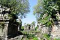
The Northwest Cambodian plains between the Dangrek range and the Tonle Sap lake, with the Phnom Kulen as a noteworthy isolated massif, are the heartland of the ancient Khmer civilization. Besides Angkor, Cambodia's four most significant pre-Angkorian and Angkorian temple towns are in this region, Sambor Prei Kuk, Prasat Bakan, Koh Ker, and Banteay Chhmar. There is no mountain barrier between these plains at the Tonle Sap and Central Thailand, this allows easy access from Bangkok to Siem Reap, which is the gateway to Angkor and other important ancient sites. The area south to the Tonle Sap lake is Battambang province, the major rice cultivation area of the country. The plains extend to the Cardamom mountains, Cambodia's largest massif.
The highest peak in Cambodia is Phnom Aural in the eastern part of the Cardamom Mountains range, rising 1,771 metres above sea level. The Cardamom (Kravan) Mountains and Elephant (Damrei) Mountains in West and Southwest Cambodia extend along the coastlines at the Gulf of Thailand, which are of a total length of 435 km, but only 150 km as the crow flies. The southwestern slopes of those highest mountains in Cambodia are the country's areas with the heaviest amount of rainfall. This is why dense tropical rain forest prevails on the western slopes, forming Cambodia's most important tropical moist broadleaf forest ecoregion. Next to Nigeria Cambodia is the country with the second-highest rate of depletion of primeval forest worldwide, 58 % disapeared between 1990 und 2005, after the civil war illegal logging and corruption looted the forest stand.
The mountain range is home to one of the largest elephant populations in Indochina and maybe still a habitat of Indochine tigers. A specific cultural feature of the mountains are jar burials, at sites of the 15th to 17th century, set out on natural rock ledges, a practice otherwise unknown in Khmer cultural history, but a typical feature of Southeast Asia. Local legends have it that the bones are the remains of Cambodian royalty. The most scenic part of the southern highlands is the area of the Kirirom national park with lots of waterfalls.
The southern coastal region is only a narrow lowland strip, sparsely populated, widening only in the Kampot region, which is between Sihanoukville and Kep. Further north the begin of the Mekong delta allows easy access to the neighbouring southern parts of Vietnam.
To the northeast, Kampong Cham province is the core area of Cambodia's Mekong valley.
The Rattanakiri Plateau and Chhlong highlands in northeastern Cambodia border on Central Vietnam (Annam), which is the eastern part of the same highland massif. This highland area is inhabited by ethnic minorities, so-called hill tribes, on both sides of the border. Particularly Mondolkiri province has scenic waterfalls. Rattanakiri province offers Cambodia's best trekking opportunities. The northeasternmost part of Cambodia is Vicharey national park. Crater lake Yak Loum is situated close to the provincial capital Banlung.
The Mekong valley separates Cambodia's northeastern highlands from the above-mentioned northwestern Dangrek range, it opens the central plains to the third neighbouring country, Laos. Kratie is a colonial town at the Mekong, a popular tourist destination because of best chances to see the rare Irrawaddy dolphins inhabiting the nearby rapids at Kampie. The northernmost Cambodian town along the Mekong is Stung Treng, a quiet backwater.
Cambodia's main administrative units are 24 provinces including the capital Phnom Penh.
20 percent of the land is used for agriculture, mainly wet rice cultivation in the more densely populated river plains in the core of Cambodia. 2800 square kilometres are irrigated. Altogether, the central plains of Cambodia cover three quarters of the country. They are dominated by the Mekong River, crossing the country's eastern half from north to southeast, and two major tributaries, viz. the Tonle Sap from the west and the Bassac river to the south. The Mekong river originates in Tibet, before entering Cambodia it flows along the Chinese border of Myanmar, through Laos, along its border with Thailand. The Tonle Sap flows into the Mekong at to Phnom Penh. Nearly at the same spot the delta distributary Bassac branches off. So Phnom Penh is situated right at the focal point of Cambodia's river system.
Part of the river system is also the Tonle Sap lake, the largest natural lake in Southeast Asia. About mid-June, the flow of the Mekong fed by monsoon rains in Southeast Asia and snow melting in the Himalayas increases to a point where its outlets through the delta cannot handle the enormous volume of water, its floodwaters then reverse the flow of the Tonle Sap river, thus, instead of an outlet the river becomes an inflow for the Tonle Sap lake. The Tonle Sap is the only river in the world changing its direction regularly. The Tonle Sap lake thereby is an important buffer avoiding too heavy floods in the Mekong basin. The Tonle Sap and Mekong basin's elevations usually is below 100 metres above sea level. The lower Mekong is home to both Irrawaddy and humpback dolphins, which are not real freshwater dolphins, and to some of the last populations on earth of the very rare Siamese crocodiles.
The central plains are surrounded by sparsely populated highlands, forming the natural borders to neighbouring countries.
The Dangrek mountains are the northern rim of the Tonle Sap basin, they consist of a steep sandstone escarpment on the southern edge of the Khorat Plateau in Northeast Thailand. The Dangrek mountains, stretching 320 km from west to east, separate Cambodia from this northeastern part of Thailand called Isan. The average elevation of the Dangrek range is about 500 meters, with the highest points reaching more than 700 metres. The most famous site in the Dangrek mountains is the spectacularly located ancient temple Preah Vihear.
The Northwest Cambodian plains between the Dangrek range and the Tonle Sap lake, with the Phnom Kulen as a noteworthy isolated massif, are the heartland of the ancient Khmer civilization. Besides Angkor, Cambodia's four most significant pre-Angkorian and Angkorian temple towns are in this region, Sambor Prei Kuk, Prasat Bakan, Koh Ker, and Banteay Chhmar. There is no mountain barrier between these plains at the Tonle Sap and Central Thailand, this allows easy access from Bangkok to Siem Reap, which is the gateway to Angkor and other important ancient sites. The area south to the Tonle Sap lake is Battambang province, the major rice cultivation area of the country. The plains extend to the Cardamom mountains, Cambodia's largest massif.
The highest peak in Cambodia is Phnom Aural in the eastern part of the Cardamom Mountains range, rising 1,771 metres above sea level. The Cardamom (Kravan) Mountains and Elephant (Damrei) Mountains in West and Southwest Cambodia extend along the coastlines at the Gulf of Thailand, which are of a total length of 435 km, but only 150 km as the crow flies. The southwestern slopes of those highest mountains in Cambodia are the country's areas with the heaviest amount of rainfall. This is why dense tropical rain forest prevails on the western slopes, forming Cambodia's most important tropical moist broadleaf forest ecoregion. Next to Nigeria Cambodia is the country with the second-highest rate of depletion of primeval forest worldwide, 58 % disapeared between 1990 und 2005, after the civil war illegal logging and corruption looted the forest stand.
The mountain range is home to one of the largest elephant populations in Indochina and maybe still a habitat of Indochine tigers. A specific cultural feature of the mountains are jar burials, at sites of the 15th to 17th century, set out on natural rock ledges, a practice otherwise unknown in Khmer cultural history, but a typical feature of Southeast Asia. Local legends have it that the bones are the remains of Cambodian royalty. The most scenic part of the southern highlands is the area of the Kirirom national park with lots of waterfalls.
The southern coastal region is only a narrow lowland strip, sparsely populated, widening only in the Kampot region, which is between Sihanoukville and Kep. Further north the begin of the Mekong delta allows easy access to the neighbouring southern parts of Vietnam.
To the northeast, Kampong Cham province is the core area of Cambodia's Mekong valley.
The Rattanakiri Plateau and Chhlong highlands in northeastern Cambodia border on Central Vietnam (Annam), which is the eastern part of the same highland massif. This highland area is inhabited by ethnic minorities, so-called hill tribes, on both sides of the border. Particularly Mondolkiri province has scenic waterfalls. Rattanakiri province offers Cambodia's best trekking opportunities. The northeasternmost part of Cambodia is Vicharey national park. Crater lake Yak Loum is situated close to the provincial capital Banlung.
The Mekong valley separates Cambodia's northeastern highlands from the above-mentioned northwestern Dangrek range, it opens the central plains to the third neighbouring country, Laos. Kratie is a colonial town at the Mekong, a popular tourist destination because of best chances to see the rare Irrawaddy dolphins inhabiting the nearby rapids at Kampie. The northernmost Cambodian town along the Mekong is Stung Treng, a quiet backwater.
Cambodia's main administrative units are 24 provinces including the capital Phnom Penh.
Recommendations:
Unknown temples are small and remote, but romantic and charming. Discover the secrets
... more
... more
Apart from circuit tours we offer an alternative, visit Angkor's temples in chronological order
... more
... more

Prasat Bakan: The largest Khmer temple compound is not Angkor Wat, but Prasat Bakan, remote and ...
more

Boat Trips: Angkor may be unsurpassed, but there are more world class tourist destinations close to ...
more

Cambodia is a perfect destination for a combination of studytrip, shopping, and beach relaxation
... more
... more
Quick inquiry
Our Services:
- Transportation arrangement around Cambodia
- Private minibus (25seats) and SUV
- Private tours in Angkor
- Guided tours in many languages
- Holiday packages around Cambodia
- Tailor-made roundtours
- Private minibus (25seats) and SUV
- Private tours in Angkor
- Guided tours in many languages
- Holiday packages around Cambodia
- Tailor-made roundtours
Our Specials:
- Forgotten temples off the beaten track
- Temple visits in chronological historical order
- Temple visits in chronological historical order
Unique Asia Travel and Tours
is an independent travel agency and tour operator registered in Cambodia, based in Siem Reap near Angkor.
We are not part of an international holding, we help to develop local tourist business.
Our company is run by locals and 100% owned by Cambodians.
For details, please check our page
Our company
We are not part of an international holding, we help to develop local tourist business.
Our company is run by locals and 100% owned by Cambodians.
For details, please check our page
Our company