


Angkor island temples (Mebons)
The largest structure built by the ancient Khmer was not Angkor Wat, but the West Baray. Even huger than Angkor’s impressive temple monuments were reservoir dams encircling vast artificial lakes. The reservoirs called Barays are charateristics of all major cities of the Angkorean era, not known before or after this classic age of Khmer history. Barays were characteristic elements of Koh Ker, Beng Mealea, Phimai and Sukothai in Thailand, Preah Khan Kampong Svay and Banteay Chhmar. (Jacques Durmaçay claims that there was one earlier Baray from the late eigth century at Wat Phu in today’s southern Laos, but Wat Phu during this early period was dominated by Cham more than by Khmer.)
The first imposing artificial lake of the Khmer was the Indratataka at Roluos, also called the Baray of Lolei. This Baray, now dry, covered an area of 2.5 square kilometres and stored 7,500,000 cubic metres water. It is sometimes ascribed to the half-legendary founder of the Khmer empire Jayavarman II, but more probably it is the work of the ingenious historical king Indravarman I, who shaped Roluos as the first imperial Khmer city. Angkor founder Yashovarman I, who was Indravarman’s son, finalized his father’s reservoir and built a temple, the Lolei, on an artificial island in the centre of this reservoir. According to this example, later major reservoirs had their respective island temples, too. They are usually called Mebons. Many Mebons are not situated in the very centre of the lake, but shifted slightly northwards.
There are four major reservoirs in the core area of Angkor, the first one was Yashovarman’s East Baray, covering 12.5 square kilometres, with a capacity of 37 million cubic metres. The East Baray dried up and is farmland with paddy cultivation now. So it’s erstwhile island temple East Mebon is not surrounded by water any more.
Srah Srang, a much smaller reservoir built under Rajendravarman II in the middle of the tenth century, is still an impressive artificial lake, but it lost its island temple, of which only foundations under the water level remain. It covers 0.3 square kilometres and has a capacity of about 1 million cubic metres.
The largest man-made water body of the Khmer civilization, in the Angkorean era as well as today, is the West Baray. It covers 16 square kilometres and contained almost 50 million cubic metres water. Today the eastern part of it is swamp area. The West Baray is rarely visited by tourists, but it is quite popular with locals for its picnicking spots and waterfront sheds. It’s small island tempel West Mebon has been under renovation during recent years, but the island can be reached by motorboat.
The largest temple building of the entire world is only half of the construction work done for the Angkor Wat. The other half is its moat. It is even huger than the Srah Srang reservoir. The sheer size of only the water body of Angkor Wat one square kilometre, containing about 4 million cubic metres water. Because of its moat that is wider in size and in proportion than at any other Khmer temple (except those Mebons in Barays), Angkor Wat can be called an island temple, too.
However, the highlight of ancient Khmer water architecture is not big in size, but impresses by its charming beauty. Neak Pean is Angkor’s island tempel par excellence. It is situated in the centre of Angkor’s last reservoir. This northern Baray was built by Jayavarman VII. The area is almost 3 square kilometres large, the capacity was almost 9 million cubic metres.
Historical significance
Barays were not the only elements of Angkor’s water management system. Actually, it also consisted of a whole network of numerous smaller reservoirs and moats and canals, distributing and storing the water of the the streams from Phnom Kulen. Bernard-Philippe Groslier (not to be confused with the even more important Angkor researcher George Groslier, who was his brother) called Angkor a “hydraulic city”. He assumed a huge population of almost 2 million people depended on paddy cultivation irrigated by a water system, of which the Barays were the core elements. His hypothesis was in compliance with Marxist theories about “hydraulic civilizations” requiring enourmous bureaucratic control for developping and maintaining huge irrigation systems. “hydraulic civilizations” were believed to be marking ancient Asian cultures as despotic in contrast to Western ones.
Jacques Dumarçay supposed, the reason for the existence of many Barays in Angkor was, that new ones were required after earlier ones had begun to silt up and because of siltation the dams were raised several times. Roland Fletcher critized the siltation model, because Yashovarman I had started the construction of the East Baray immediately after finalizing his father’s Baray Indratataka and water levels depend on the height of intake points, not that of dams. However, archaeological evidence indicates, that indeed changing water ressources led to construction modifications at Angkor’s Barays. On the other hand, some critics of the “hydraulic city” model suggested, that Barays were no functional buildings at all, but only sacred architecture with cosmic symbolism, this means, a special kind of temples, with only enourmously enlarged moats. Reasons for this assumption of religious funtions only were missing evidence, how the outlet of water should have worked, or even topographic calculations, that water supply by the Barays would have been technically impossible or at least effectless. So the answer to the question, what was the purpose the vast Barays served for, is crucial for an understanding of the economic basis of the Angkor civilization.
It seems that both parties are partially right, after recent studies by Christophe Pottier of the École française d’Extrême-Orient indeed found outlets of the Eastern and Western Baray, surprisingly at their eastern dams, instead of the longer southern dams where the water should be expected to leave according to natural inclination. But there were dispersion canals, too. However, the Barays seem to have played a much less important role in contributing to water supplies for wet rice cultivation than those plenty of smaller reservoirs of villagers that served for regulating seasonal changes of water supply, too. So the dimensions of the Barays remain to be a mystery. Fletcher and Pottier came to the conclusion, that Barays served not so much for wet rice cultivation in the areas in their immediate neighbourhood below their dams, but for transporting water seasonally along long canals in order to support paddy cultivation in the area of the Tonle Sap, where seasonal water levels change more dramatically. So the Barays could have served more for supporting flood-retreat paddy farming than for wet rice cultivation. But the full understanding of the Khmer water management system – and its changes in the course of time – will remain to be the major field of research in southeastasien history, for future anthropologists and scientists, and may be a clue to solve the other famous puzzle: What were the reasons for the decline of the Angkorian empire?
Beyond doubt, Barays were not mere functional buildings, but religious monuments at the same time. Maybe they served for royal water and fertility ceremonies and festivals. So be aware, the Mebon island temples you are visiting today are only a small interior part of those ancient gigantic sacred monuments.
__________
_58bbe4238e90c.jpg)
Lolei temple in Roluos
Lolei, sometimes spelt Loley, is the youngest and smallest of the three most important Roluos temples, less photogenic than the similar Preah Ko. But the historical background of the Lolei temple is remarkable in many respects. It was consecrated in 893, its promoter was Yashovarman I (889-910), who shifted the capital from Hariharalaya, the present-day Roluos, to a new 16 square kilometres large fortified city called Yashodharapura. It encompassed the area of the later Angkor Wat and was the first city and capital in the area we call Angkor. Thus, Yashovarman, who erected the Lolei temple in commemoration of his father, Roluos-king Indravarman I, can be titled the founder or initial king of the most famous ancient Khmer capital Angkor, where the Bakheng became his state temple. Yashovarman also constructed the East Baray, the main source of Angkor's water supply and economical wealth during four centuries to come. But Yashovarman also completed the 3.8 km long and 800 m wide Baray of his father's capital Roluos. This tank once called Indratataka, "sea of Indra", like the East Baray, is dry now. The Lolei was built on an artificial island slightly north to the centre of this reservoir, which therefore is also called the Baray of Lolei. As the Bakong in Rolous was a kind of model for Angkor's Khmer temple-pyramids, so the Lolei became the prototype for the Khmer lake-temples, particularly the East- and West-Mebon in the East- and West-Barays of Angkor. The embankments of the elongated rectangular Baray of Lolei run strictly east-west and north-south, slightly divergent from the natural inclination. Similarly the later Angkor Barays extended in east-west-direction.
The ancestor temple Lolei consists of four brick towers, dedicated not only to the parents, but also to the maternal grandparents of Yashovarman I. The southwest tower is half broken, the southeast Prasat collapsed in 1968. There is some speculation that two more Prasats were planned at the northern side, making the Lolei even more alike Preah Ko, which was built by Yashovarman's father and predecessor Indravarman. However, the northern towers were never erected. The four Prasats were covered with stucco, some parts of excellent quality are still visible. Sandstone lintels and colonettes bear exquisite stone carvings. The false doors are monolithic. The eastern towers are protected by male guardian sculptures called Dvarapalas, they show with characteristics of Shiva, whereas the western towers dedicated to female ancestors show female devatas instead. A small cruciform sandstone channel in between the four towers is an unusual feature. A square pedestal, supposedly for a Linga, is placed at the intersection of these channels.
__________
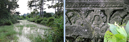
Trapeang Srangae moat
In a certain sense almost all majr Angkor temples can be called „island temples“ insofar as they are surrounded by moats. On the other hand, island temples in Barays can be interprted as normal temples with an extraordinarily wide moat.
A Southeastasian temple, in compliance with Indian examples, was an ample Mandala, a geometric pattern representing the the cosmic structure spiritually, with an arrangement of symbols of minor deities surrounding the main idol in the centre. The exterorior enclosure waals formed a square or at least a rectangle according to the four cardinal directions. It is typical for Khmer temples that the borderline between sacred and profane areas was additionally emphasized by rectangular moats. Water, because of its life-giving and purifying qualities, played a core role in the imperial ideology of the agrarian Khmer culture. An inscription compares moats and reservoirs of Angkor with tributaries of India’s sacred river Ganges. Furthermore, moats symbolized the exterior ocean of the world.
There are some temples of which the moats are better preserved than the stone structures themselves. An Example for this is Trapeang Srangae, situated to the east of Preah Ko and to the north-east of Bakong in Roluos. The wide rmoat in the jungle is in a sound condition, solely from the east it allows access to a temple compound, in which otherwise only foundation walls and some lintels ares scattered on the ground.
__________

Trapeang Phong marshland
Apart from moats there was another form of Khmer water architecture, viz. Trapeangs. Trapeang temples have no continuous expanses of water, but smalöler separate ponds around them or in front of them. Such a single pond is called a Trapeang.
A Trapeang was discovered at the temple Trapeang Phing in Roluos, too, but it is hardly recognizable for today’s visitors.
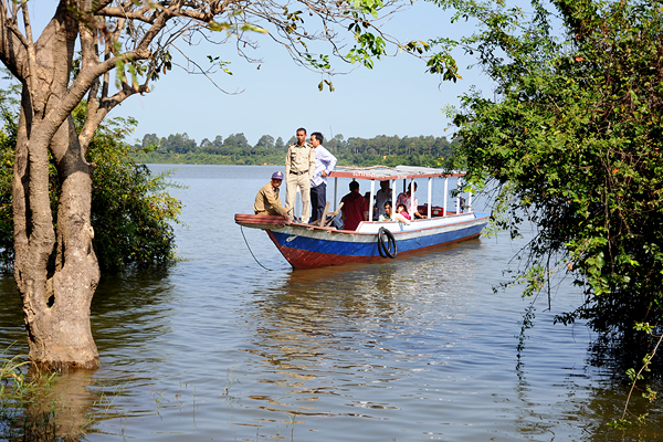
However, Trapeang Phong is an “island temple” in another respect. It is situated in the swamp zone of the Great Lake Tonle Sap, thus, during the summer and autumn months it can be visited only by boat, you have to ask the locals for hiring one. Then you really enjoy the atmosphere of travelling to an island.
Originally Trapeang Phong was an ensemble of füur Prasat towers in irregular order. But three of them are hardly recognizable. The fourth one is a brick tower in a fair condition. The tall superstructure has four tiers.
Trapeang Phong is from the middle of the ninth century, this mean, besides Prei Monti, located 1 km further north, it is one of the erliest temples of the dawning Angkorian era.
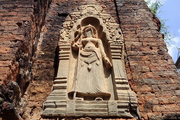
Well worth seeing are the Devata sculptures and lintels. Its female Devatas, sometimes erroneously called “Apsaras”, though they are no celestial dancers, but guardians, are the first known examples of such sculptures in niches. Some of the colonnettes at doors and false doors are round, others octagonal.
__________

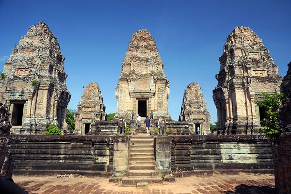
East Mebon temple
Apart from the Angkor Wat, the East Mebon was the largest Khmer island temple, but it is not situated on an island any more since the East Baray dried up during the first half of the scond millennium. Inscriptions state that Kavindrarimathana was charged by the king to build edifices in the middle of Lake Yashodhara, the East Baray.
The East Mebon is an imperial symbol of continuity of the dynasty as well as the capital. The builder Rajendravarman II was a cousin of his predecessor Harshavarman II. Harshavarman had not been the designated heir to the trone, but was supported by Rajendravarman in seizing power. Those days Koh Ker, not Angkor, was the Khmer capital. After Harshavarman’s death his powerful supporter became king, but could have been regarded as a usurper. Building the East Mebon was a means to the end to legitimize his rule. It did so by insinuating a continuity of a higher order: The East Mebon was not only Rajendravarman’s ancestor temple, it meant a shift back from Koh Ker to Angkor, the city of Rajendravarman’s uncle Yashovarman, who had been a fully legitimate heir to the throne. Like Yashovarman had honoured his predecessor Indravarman by building the island temple Lolei in King Indravarman’s reservoir Indratataka, now Rajendravarman built a similar, but much bigger ancestor temple on an island of King Yashovarman’s reservoir Yashodharatataka, the East Baray. Obviously, this analogy serves to emphasize the continuity of Angkorian rule.
However, there is something special and mysterious: Why is the East Mebon not simply an island temple on ground level, but a kind of elevated temple pyramid at the same time? And why is it not only an ancestor temple, but a state temple, too? It contained the state Lingam bearing the king’s name, the Linga Rajendreshvara. This is exactly in the tradions of royal state temples. And this is all the more surprising as Rajendravarman built the largest temple mountain of the tenth century, too. Pre Rup’s architect was the same who constructed the East Mebon. So did Rajendravarman build two state temples, in contrast to all other Khmer kings before and after him? But in case he had only one, it must have been the East Mebon and not Pre Rup, because the name of the Lingam of the East Mebon symbolizing the king’s power is that of the king, the name of the Pre Rup Lingam refers not to the living, but to a deseased king. Many believe, that Pre Rup was not Rajendravarman’s state temple, but his funerary temple. The ambiguity of the East Mebon’s function – ancestor and state temple at the same time – could be the reason for its hybrid type of architecture, partly flat temple on an island like Lolei, partly temple mountain like Indravarman’s Bakong and Yashovarman’s Bakheng.
The East Mebon was a three-tiered temple pyramid with a low inclination angle, neither a temple mountain nor a flat temple. Today it seems to be taller than it really was, because the visitor will view it from the bottom of the former lake. What seems to be a first tier of the pyramid now, was indeed just above the water surface. To judge by the laterite steps that surround the East Mebon platform, the original depth of water was approximately three metres.
The lower tiers were of laterite. The upper tier, measuring 30 m by 30 m, was built in sandstone and has five brick Prasats in quincunx order. The towers were similar in style to the Roluos period of King Indravarman I. For a more detailed description of the architecture of the East Mebon please visit our page “Angkor pyramids”.
__________

Srah Srang reservoir
Real Barays retained water above ground level behind elevated dams. In contrast to Barays, Srahs were artificial swales dug into the ground. Srah Srang, also spelt Sras Srang, is a combination, both dug and embanked. In size it is midway, too, namely between Baray lake and Trapeang pool. Unlike to the nearby East Baray the Srah Srang reservoir dug out below the natural water level, is filled with water. Now it is not a place for ritual baths any more, but a quite scenic rectangular lake.
Nothing remains of the Mebon island temple of Srah Srang, though it had one, its basement is now under the water level, but can be recognized at the end of dry season even without diving for it. It is not placed in the centre.
French archeologists found a necropolis close to the rexervoir. Srah Srang, the “Royal Bath”, is ascribed to the reign of Rajendravarman II, but sometimes supposed to be from a much later date, namely from the Buddhist Bayon style period of King Jayavarman VII at the end of the 12th century. Certainly a first Srah was constructed already in the 10th century, but it got a new laterit and sandstone cladding in the 12th century. The platform with Naga balustrades and lion guardians is definitely in the style of Bayon and was connected to the nearby first major flat temple of Jayavarman VII, Banteay Kdei.
The platform was under renovation and the sculptures removed for restauration in 2013. The platform is a popular sunrise point of Angkor. Its immediate surrounding offers the best restaurant area inside the Archaeological Park.
__________
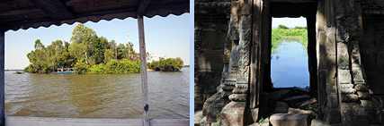
West Mebon island temple
The West Mebon is located on an artificial island of almost 200 m diameter in the centre of the West Baray, which was the largest artificial lake of the Khmer empire, 8 km long and 2 km wide, like the East Baray elongated on an East-West-axis. Baray and Mebon are from the middle of the 10th century, most probably begun under Suryavarman I and finalized by Udayadityavarman II.
Unlike the East Mebon, the West Mebon island temple was flat, on ground level. Only the eastern enclosure wall of the temple copound of 70 metres square is preserved. Originally it had three Gopuram gates with small towers on each side, only two towers are preserved. They are covered with bas-reliefs depicting animals in the style of Baphuon. The wall was rounded on top, with little niches. Inside the compound was a basin filled with water. A causeway from the east ended in a cross in the centre of this basin with foundations of a sanctuary.
No inscription has been found here, but an inscription of Preah Khan mentions that the island temple was dedicated to Vishnu. In 1936 parts of a gigantic bronze sculpture of the reclining Vishnu were excavated on the island, modern local legend has it, that it was discovered after a villager’s dream that a Buddha statue asked to be unburied.
In 2013 dykes were built to protect the West Mebon island. Restauration work at the temple was ongoing 2914. The island can be reached by hiring a boat at the southern dam of the Baray, where the modern outlet is located and the paved road from Siem Reap ends at the lake. The West Baray is popular with locals as a weekend picnic spot.
__________
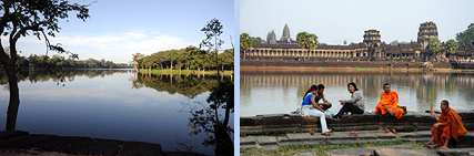
Angkor Wat Moat
Major Khmer temples have moats, the vastest Khmer temple has the largest moat, the outside perimeter extends more than five kilometres, the width is almost 200 metres. That’s the size of an impressive reservoir. And it really served for irrigation, too, disperson canals habe been discovered.
Due to its dimensions and its proportions, water, that charakteristic element of Khmer architecture, is more dominant at the Angkor Wat than at any other temple in the world. You cannot really compare it to a moat of European castles, this moat is a lake. Digging and cladding it required as much work force as the construction of the gigantic temple proper. The jungle had to be removed, depending on the original ground level at least 1,5 million or even 4 million cubic metres earth had to be removed. Much of the soil was transported to the core of the new artificial island and has been contained inside the outer walls of the temple enclosures, with laterite structures and sandstone cladding, making Angkor Wat an artificial mountain.
The moat of Angkor Wat played and continues to play a crucial role for the stability and the state of preservation of this extraordinary monument. The underground is silt and sand and swamp. In this day and age construction of high buildings is not permitted in the Siem Reap area because of the inapplicable condition of the soil. But ancient engineers used several technical tricks, not all of them fully understood till the present day, to stabilize the enourmous temple stucture that was created as a ship of stone in a swamp, Angkor Wat is not supported by underground constructions like Venice or the Taj Mahal, indeed, Angkor Wat swims. But changing water quantities in the underground due to seasonal changes of water levels, if not equally distributed below the monument, could fracture it. The ingenious giant moat contributes to keep the underground density relatively stable all year round. It does so by collecting the run-off of the temple compound during the rainy season, for reducing the water quantity below the temple builing, in order to reduce upwards surge. On the other hand, during the dry season, the soil below the temple compound can absorb water from the moat. Thus the moat prevented groundwater from both rising too high or falling too low. By the way, one reason why the Baphuon, Angkor’s second largest temple, collapsed after only a few centuries, was the lack of a moat.
Furthermore, the moat is one main reason why Angkor Wat has never been reconquered by the jungle. The forest did not spread as much across this wide moat as in the case of temples with narrow moats. Angkor Wat’s moat also served as a defensive bulwark for the city on the temple island.
The moat surrounded the external (counted fourth from the centre) enclosure of the temple compound, its laterite walls are bordered by sandstone steps. The moat is crossed only on two axes, from the east by a simple earth dam, that could erstwhile have served to transport construction materials and sustainment supply to the island, and from the west by a prestigious sandstone causeway, 200 metres long and 12 metres wide. Pillars along its sides that support its corbelled edge, of which only a few are still visible. A slightly elevated cruciform terrace, guarded by lion sculptures, precedes the causeway. Both sides are flanked by Naga-balustrades.
The Naga-serpents, of course, indicate the mythic symbolism of the moat’s water. It reprensents the cosmic ocean, in contrast to the temple mountain that symbolizes the cosmic mountain called Meru.

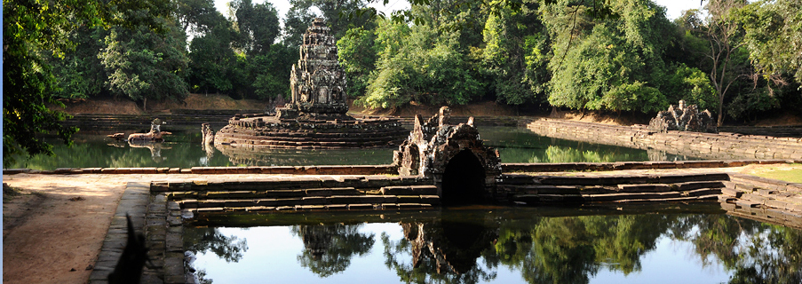
Neak Pean island temple
A major task of Buddhist kings, particularly for an emperor, a “Chakravartin”, was the construction of reservoirs. So Angkor’s king introducing Mahayana-Buddhism as state cult, Jayavarman VII, built a new reservoir, the Jayatataka, this means “Victory Lake”. Today this reservoir is a swamp and usually called called "Veal Reach Dak" by locals, meaning "plain of the royal reservoir". On maps and in guidebooks you will also find the names “Northern Baray” or “Baray of Preah Khan”, since it is situated in the very same east-west axis of the Preah Khan temple, in front of it to the east. The Jayatataka measures 3,500 m by 900 m. The island of 350 m diameter with a temple in the centre of this North Baray is called Neak Pean.
Jayavarman VII. is famous for building hospitals in accordance with the Mahayana-Buddhist teaching of care as means of salvation or highest end in itself. Neak Pean was not one of those famous hospitals, but most probably a kind of spa for pilgrims, who could bath in sacred pools fed with holy water. Neak Pean seems to have been dedicated to the Buddha originally, but later on was changed to the Bodhisattva Avalokiteshvara, who is called Lokeshvara in Cambodia. Lokeshvara is the healer of the sick and lame. Lokeshvara did not play a significant role in the Khmer religion and iconography before Jayavarman VII. Even in the early phase of his Jayavarman’s reign Lokeshvara was less venerated than the Buddha. But this changed in the second half of his reign, when Angkor Thom and the Bayon temple became the major projects of this king.
The inscription of Preah Khan claims the water that the water of the Jayatataka was holier than that of Prayag. Prayag is the modern Allahabad in India, where Ganges and Jamuna and the mythical Saraswati meet, the junction of three rivers is called a Triveni Sangam. Accordingly, the inscription of Preah Khan mentions as Angkor’s three holy waters the East Baray for Shiva, the West Baray for Vishnu and Jayavarman’s new North Baray for Buddha.
The original name of the island temple was Rajashri, “king’s shining”. The modern name “Neak Pean” means “coiled serpents” and alludes to the imposing Naga balustrades around the basis of the circular central Prasat, raising their heads to the east and tails to the west. Neak Pean’s design is unique in Khmer architecture, though it is not the only round Prasat, that of the Bayon has a circular layout, too. But the circular platform surrounded by the bodies of the two Nagas (Neak) mentioned above is unprecedented.
Neak Pean’s exceptional beauty emanates from another unparalleled feature, Neak Pean is first and foremost an ensemble of ponds in a Mandala layout, it’s circular central shrine is an island within the island. The central platform of 14 m diameter is situated in the middle of a square basin of 70 metres. Its sandstone foundation has eight steps running around the platform. The upper step has the layout of a lotus. Thus the core sanctuary springs up from a lotus bud on a pond.
This central Prasat is faced by a statue of the horse Balaha placed in the pond, partly under water. It is depicted saving drowning sailors clinging to his flanks and tail. Horse-king Balaha (Valaha) was an incarnation of Bodhisattva Avalokitesvara. It was identified with a flying white horse with five heads rescuing devotees from a sinking ship threatened by a female sea demon trying to devour them.
The larger pond sits at the axis of a cross of four more square ponds in the cardinal directions, each of them 24 m by 24 m. Originally the five ponds were surrounded by eight more square pools in a lotus pattern.
There are four sandstone structures at the cardinal points of the central pond, connecting it to the neigbouring smaller ponds. During the rainy season, only the roofs can be seen. Inside those four structures, there are gargoyles of four different forms: a lion to the south pool, a horse to the west, an elephant to the north, and a man's face to the east. It seems that water would only emerge from the gargoyles' mouthes when priests or pilgrims poured water from the main pond into the small receptacle above the backside of the gargoyles.
An inscription stated that Neak Pean was "a sacred island, drawing its charm from its ponds and clearing away the sins of those who approach it". This is why Neak Pean is supposed to have served an absolution function and medical purposes. The water of the ponds was thought to have sacred healing power. The water was consecrated by flowing through the mouth of one of the sacred animals mentioned above. Maybe, they symbolized the four elements, lion for fire, horse for air, elephant for water, and man for earth. It is assumed, each sick person was sent to the pool of that element believed to be of specific healing power for his desease or according to his astrological character.
There is another interpretation of Neak Pean, namely that its central pond symbolizes the mythical lake Anavatapta. The location of the real lake associated with Anavatapta is in the Himalayas, near Mt. Kailash. In this area there are springs of the most important and sacred rivers of India, leaving into four different directions (approximately). The rivers are Ganga, Jamuna, Indus and Brahmaputra. The four springs at Anavatapta are said to be spewed from the mouths of a lion, an elephant, a horse, and a bull. In Buddhist traditions those four animals became common symbols of the four directions, representing this world. For example, they are well-known from the Ashoka capital in Sarnath. They are a common motif at Budhist temples in Sri Lanka, too. The bull is replaced by a man at Neak Pean. This is strange and a reason to doubt Neak Pean's association with the Anavatapta myth. However, the bull is also removed from 12th century moonstones in Sri Lanka. Already at the capitals of the four cardinal direction gates (Toranas) of the great stupa in Sanchi in India bull and horse are missing and replaced by a second kind of elephant and by dwarfs with human faces. By the way, both interpretations of Neak Pean, medical pilgrimage site and Anavatapta symbol, do not at all contradict each other, as Lake Anavatapta was believed to be of healing power, too.
The Balaha sculpture and the animal and human gargoyles should be seen during the dry season. But visitors are not allowed to enter the area of the pools any more. They only can view the arrangement of pools from the northern edge. This is why the wet season, when the pools are full of water, is now more recommendable for a visit.
There are figures of Bodhisattva Avalokitesvara on the wall of the central Prasat, which is built of sandstone. Above the one to the north, whose head was stolen in 1982, there is a pediment carving depicting prince Siddharta's "Great Departure" from his life in a palace to a search for salvation. The east pediment shows the cutting of his hair, symbol for the begin of his life as a hermit, the west pediment depicts him meditating under a tree. Each corner has statues depicting Airavata, the three-headed elephant being the mount of Indra.
Neak Pean had lion statues, which were made of bronze. They possibly symbolized Kubera, the god of wealth. In the 14th century, Siamese invaders conquered Angkor. The bronze lions from Neak Pean were looted and brought to the Siam capital Ayyuthaya. But when the Burmese seized Ayyuthaya, they took the Neak Pean bronze lions to Mandalay, where those statues remained to be till the present day.
Though dedicated to Buddha and Lokeshvara, Neak Pean contained several Hindu images, too. A stone sculpture of Vishnu was found on the west side of the island, and Lingas at the north side. Maybe, Neak Pean was even a former royal Hindu site.
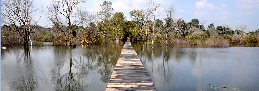
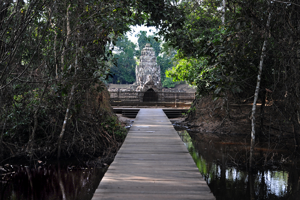
There is a wooden footbridge from the car park at the Grand Circuit route crossing the Northern Baray swamp and leading to the observation platform of Neak Pean. As already mentioned, access to the pond area is not permitted any more.
The first imposing artificial lake of the Khmer was the Indratataka at Roluos, also called the Baray of Lolei. This Baray, now dry, covered an area of 2.5 square kilometres and stored 7,500,000 cubic metres water. It is sometimes ascribed to the half-legendary founder of the Khmer empire Jayavarman II, but more probably it is the work of the ingenious historical king Indravarman I, who shaped Roluos as the first imperial Khmer city. Angkor founder Yashovarman I, who was Indravarman’s son, finalized his father’s reservoir and built a temple, the Lolei, on an artificial island in the centre of this reservoir. According to this example, later major reservoirs had their respective island temples, too. They are usually called Mebons. Many Mebons are not situated in the very centre of the lake, but shifted slightly northwards.
There are four major reservoirs in the core area of Angkor, the first one was Yashovarman’s East Baray, covering 12.5 square kilometres, with a capacity of 37 million cubic metres. The East Baray dried up and is farmland with paddy cultivation now. So it’s erstwhile island temple East Mebon is not surrounded by water any more.
Srah Srang, a much smaller reservoir built under Rajendravarman II in the middle of the tenth century, is still an impressive artificial lake, but it lost its island temple, of which only foundations under the water level remain. It covers 0.3 square kilometres and has a capacity of about 1 million cubic metres.
The largest man-made water body of the Khmer civilization, in the Angkorean era as well as today, is the West Baray. It covers 16 square kilometres and contained almost 50 million cubic metres water. Today the eastern part of it is swamp area. The West Baray is rarely visited by tourists, but it is quite popular with locals for its picnicking spots and waterfront sheds. It’s small island tempel West Mebon has been under renovation during recent years, but the island can be reached by motorboat.
The largest temple building of the entire world is only half of the construction work done for the Angkor Wat. The other half is its moat. It is even huger than the Srah Srang reservoir. The sheer size of only the water body of Angkor Wat one square kilometre, containing about 4 million cubic metres water. Because of its moat that is wider in size and in proportion than at any other Khmer temple (except those Mebons in Barays), Angkor Wat can be called an island temple, too.
However, the highlight of ancient Khmer water architecture is not big in size, but impresses by its charming beauty. Neak Pean is Angkor’s island tempel par excellence. It is situated in the centre of Angkor’s last reservoir. This northern Baray was built by Jayavarman VII. The area is almost 3 square kilometres large, the capacity was almost 9 million cubic metres.
Historical significance
Barays were not the only elements of Angkor’s water management system. Actually, it also consisted of a whole network of numerous smaller reservoirs and moats and canals, distributing and storing the water of the the streams from Phnom Kulen. Bernard-Philippe Groslier (not to be confused with the even more important Angkor researcher George Groslier, who was his brother) called Angkor a “hydraulic city”. He assumed a huge population of almost 2 million people depended on paddy cultivation irrigated by a water system, of which the Barays were the core elements. His hypothesis was in compliance with Marxist theories about “hydraulic civilizations” requiring enourmous bureaucratic control for developping and maintaining huge irrigation systems. “hydraulic civilizations” were believed to be marking ancient Asian cultures as despotic in contrast to Western ones.
Jacques Dumarçay supposed, the reason for the existence of many Barays in Angkor was, that new ones were required after earlier ones had begun to silt up and because of siltation the dams were raised several times. Roland Fletcher critized the siltation model, because Yashovarman I had started the construction of the East Baray immediately after finalizing his father’s Baray Indratataka and water levels depend on the height of intake points, not that of dams. However, archaeological evidence indicates, that indeed changing water ressources led to construction modifications at Angkor’s Barays. On the other hand, some critics of the “hydraulic city” model suggested, that Barays were no functional buildings at all, but only sacred architecture with cosmic symbolism, this means, a special kind of temples, with only enourmously enlarged moats. Reasons for this assumption of religious funtions only were missing evidence, how the outlet of water should have worked, or even topographic calculations, that water supply by the Barays would have been technically impossible or at least effectless. So the answer to the question, what was the purpose the vast Barays served for, is crucial for an understanding of the economic basis of the Angkor civilization.
It seems that both parties are partially right, after recent studies by Christophe Pottier of the École française d’Extrême-Orient indeed found outlets of the Eastern and Western Baray, surprisingly at their eastern dams, instead of the longer southern dams where the water should be expected to leave according to natural inclination. But there were dispersion canals, too. However, the Barays seem to have played a much less important role in contributing to water supplies for wet rice cultivation than those plenty of smaller reservoirs of villagers that served for regulating seasonal changes of water supply, too. So the dimensions of the Barays remain to be a mystery. Fletcher and Pottier came to the conclusion, that Barays served not so much for wet rice cultivation in the areas in their immediate neighbourhood below their dams, but for transporting water seasonally along long canals in order to support paddy cultivation in the area of the Tonle Sap, where seasonal water levels change more dramatically. So the Barays could have served more for supporting flood-retreat paddy farming than for wet rice cultivation. But the full understanding of the Khmer water management system – and its changes in the course of time – will remain to be the major field of research in southeastasien history, for future anthropologists and scientists, and may be a clue to solve the other famous puzzle: What were the reasons for the decline of the Angkorian empire?
Beyond doubt, Barays were not mere functional buildings, but religious monuments at the same time. Maybe they served for royal water and fertility ceremonies and festivals. So be aware, the Mebon island temples you are visiting today are only a small interior part of those ancient gigantic sacred monuments.
__________
Lolei temple in Roluos
Lolei, sometimes spelt Loley, is the youngest and smallest of the three most important Roluos temples, less photogenic than the similar Preah Ko. But the historical background of the Lolei temple is remarkable in many respects. It was consecrated in 893, its promoter was Yashovarman I (889-910), who shifted the capital from Hariharalaya, the present-day Roluos, to a new 16 square kilometres large fortified city called Yashodharapura. It encompassed the area of the later Angkor Wat and was the first city and capital in the area we call Angkor. Thus, Yashovarman, who erected the Lolei temple in commemoration of his father, Roluos-king Indravarman I, can be titled the founder or initial king of the most famous ancient Khmer capital Angkor, where the Bakheng became his state temple. Yashovarman also constructed the East Baray, the main source of Angkor's water supply and economical wealth during four centuries to come. But Yashovarman also completed the 3.8 km long and 800 m wide Baray of his father's capital Roluos. This tank once called Indratataka, "sea of Indra", like the East Baray, is dry now. The Lolei was built on an artificial island slightly north to the centre of this reservoir, which therefore is also called the Baray of Lolei. As the Bakong in Rolous was a kind of model for Angkor's Khmer temple-pyramids, so the Lolei became the prototype for the Khmer lake-temples, particularly the East- and West-Mebon in the East- and West-Barays of Angkor. The embankments of the elongated rectangular Baray of Lolei run strictly east-west and north-south, slightly divergent from the natural inclination. Similarly the later Angkor Barays extended in east-west-direction.
The ancestor temple Lolei consists of four brick towers, dedicated not only to the parents, but also to the maternal grandparents of Yashovarman I. The southwest tower is half broken, the southeast Prasat collapsed in 1968. There is some speculation that two more Prasats were planned at the northern side, making the Lolei even more alike Preah Ko, which was built by Yashovarman's father and predecessor Indravarman. However, the northern towers were never erected. The four Prasats were covered with stucco, some parts of excellent quality are still visible. Sandstone lintels and colonettes bear exquisite stone carvings. The false doors are monolithic. The eastern towers are protected by male guardian sculptures called Dvarapalas, they show with characteristics of Shiva, whereas the western towers dedicated to female ancestors show female devatas instead. A small cruciform sandstone channel in between the four towers is an unusual feature. A square pedestal, supposedly for a Linga, is placed at the intersection of these channels.
__________
Trapeang Srangae moat
In a certain sense almost all majr Angkor temples can be called „island temples“ insofar as they are surrounded by moats. On the other hand, island temples in Barays can be interprted as normal temples with an extraordinarily wide moat.
A Southeastasian temple, in compliance with Indian examples, was an ample Mandala, a geometric pattern representing the the cosmic structure spiritually, with an arrangement of symbols of minor deities surrounding the main idol in the centre. The exterorior enclosure waals formed a square or at least a rectangle according to the four cardinal directions. It is typical for Khmer temples that the borderline between sacred and profane areas was additionally emphasized by rectangular moats. Water, because of its life-giving and purifying qualities, played a core role in the imperial ideology of the agrarian Khmer culture. An inscription compares moats and reservoirs of Angkor with tributaries of India’s sacred river Ganges. Furthermore, moats symbolized the exterior ocean of the world.
There are some temples of which the moats are better preserved than the stone structures themselves. An Example for this is Trapeang Srangae, situated to the east of Preah Ko and to the north-east of Bakong in Roluos. The wide rmoat in the jungle is in a sound condition, solely from the east it allows access to a temple compound, in which otherwise only foundation walls and some lintels ares scattered on the ground.
__________
Trapeang Phong marshland
Apart from moats there was another form of Khmer water architecture, viz. Trapeangs. Trapeang temples have no continuous expanses of water, but smalöler separate ponds around them or in front of them. Such a single pond is called a Trapeang.
A Trapeang was discovered at the temple Trapeang Phing in Roluos, too, but it is hardly recognizable for today’s visitors.
However, Trapeang Phong is an “island temple” in another respect. It is situated in the swamp zone of the Great Lake Tonle Sap, thus, during the summer and autumn months it can be visited only by boat, you have to ask the locals for hiring one. Then you really enjoy the atmosphere of travelling to an island.
Originally Trapeang Phong was an ensemble of füur Prasat towers in irregular order. But three of them are hardly recognizable. The fourth one is a brick tower in a fair condition. The tall superstructure has four tiers.
Trapeang Phong is from the middle of the ninth century, this mean, besides Prei Monti, located 1 km further north, it is one of the erliest temples of the dawning Angkorian era.
Well worth seeing are the Devata sculptures and lintels. Its female Devatas, sometimes erroneously called “Apsaras”, though they are no celestial dancers, but guardians, are the first known examples of such sculptures in niches. Some of the colonnettes at doors and false doors are round, others octagonal.
__________
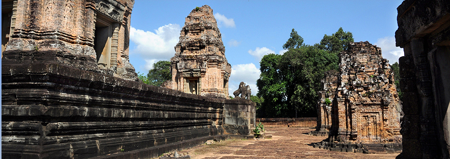
East Mebon temple
Apart from the Angkor Wat, the East Mebon was the largest Khmer island temple, but it is not situated on an island any more since the East Baray dried up during the first half of the scond millennium. Inscriptions state that Kavindrarimathana was charged by the king to build edifices in the middle of Lake Yashodhara, the East Baray.
The East Mebon is an imperial symbol of continuity of the dynasty as well as the capital. The builder Rajendravarman II was a cousin of his predecessor Harshavarman II. Harshavarman had not been the designated heir to the trone, but was supported by Rajendravarman in seizing power. Those days Koh Ker, not Angkor, was the Khmer capital. After Harshavarman’s death his powerful supporter became king, but could have been regarded as a usurper. Building the East Mebon was a means to the end to legitimize his rule. It did so by insinuating a continuity of a higher order: The East Mebon was not only Rajendravarman’s ancestor temple, it meant a shift back from Koh Ker to Angkor, the city of Rajendravarman’s uncle Yashovarman, who had been a fully legitimate heir to the throne. Like Yashovarman had honoured his predecessor Indravarman by building the island temple Lolei in King Indravarman’s reservoir Indratataka, now Rajendravarman built a similar, but much bigger ancestor temple on an island of King Yashovarman’s reservoir Yashodharatataka, the East Baray. Obviously, this analogy serves to emphasize the continuity of Angkorian rule.
However, there is something special and mysterious: Why is the East Mebon not simply an island temple on ground level, but a kind of elevated temple pyramid at the same time? And why is it not only an ancestor temple, but a state temple, too? It contained the state Lingam bearing the king’s name, the Linga Rajendreshvara. This is exactly in the tradions of royal state temples. And this is all the more surprising as Rajendravarman built the largest temple mountain of the tenth century, too. Pre Rup’s architect was the same who constructed the East Mebon. So did Rajendravarman build two state temples, in contrast to all other Khmer kings before and after him? But in case he had only one, it must have been the East Mebon and not Pre Rup, because the name of the Lingam of the East Mebon symbolizing the king’s power is that of the king, the name of the Pre Rup Lingam refers not to the living, but to a deseased king. Many believe, that Pre Rup was not Rajendravarman’s state temple, but his funerary temple. The ambiguity of the East Mebon’s function – ancestor and state temple at the same time – could be the reason for its hybrid type of architecture, partly flat temple on an island like Lolei, partly temple mountain like Indravarman’s Bakong and Yashovarman’s Bakheng.
The East Mebon was a three-tiered temple pyramid with a low inclination angle, neither a temple mountain nor a flat temple. Today it seems to be taller than it really was, because the visitor will view it from the bottom of the former lake. What seems to be a first tier of the pyramid now, was indeed just above the water surface. To judge by the laterite steps that surround the East Mebon platform, the original depth of water was approximately three metres.
The lower tiers were of laterite. The upper tier, measuring 30 m by 30 m, was built in sandstone and has five brick Prasats in quincunx order. The towers were similar in style to the Roluos period of King Indravarman I. For a more detailed description of the architecture of the East Mebon please visit our page “Angkor pyramids”.
__________
Srah Srang reservoir
Real Barays retained water above ground level behind elevated dams. In contrast to Barays, Srahs were artificial swales dug into the ground. Srah Srang, also spelt Sras Srang, is a combination, both dug and embanked. In size it is midway, too, namely between Baray lake and Trapeang pool. Unlike to the nearby East Baray the Srah Srang reservoir dug out below the natural water level, is filled with water. Now it is not a place for ritual baths any more, but a quite scenic rectangular lake.
Nothing remains of the Mebon island temple of Srah Srang, though it had one, its basement is now under the water level, but can be recognized at the end of dry season even without diving for it. It is not placed in the centre.
French archeologists found a necropolis close to the rexervoir. Srah Srang, the “Royal Bath”, is ascribed to the reign of Rajendravarman II, but sometimes supposed to be from a much later date, namely from the Buddhist Bayon style period of King Jayavarman VII at the end of the 12th century. Certainly a first Srah was constructed already in the 10th century, but it got a new laterit and sandstone cladding in the 12th century. The platform with Naga balustrades and lion guardians is definitely in the style of Bayon and was connected to the nearby first major flat temple of Jayavarman VII, Banteay Kdei.
The platform was under renovation and the sculptures removed for restauration in 2013. The platform is a popular sunrise point of Angkor. Its immediate surrounding offers the best restaurant area inside the Archaeological Park.
__________
West Mebon island temple
The West Mebon is located on an artificial island of almost 200 m diameter in the centre of the West Baray, which was the largest artificial lake of the Khmer empire, 8 km long and 2 km wide, like the East Baray elongated on an East-West-axis. Baray and Mebon are from the middle of the 10th century, most probably begun under Suryavarman I and finalized by Udayadityavarman II.
Unlike the East Mebon, the West Mebon island temple was flat, on ground level. Only the eastern enclosure wall of the temple copound of 70 metres square is preserved. Originally it had three Gopuram gates with small towers on each side, only two towers are preserved. They are covered with bas-reliefs depicting animals in the style of Baphuon. The wall was rounded on top, with little niches. Inside the compound was a basin filled with water. A causeway from the east ended in a cross in the centre of this basin with foundations of a sanctuary.
No inscription has been found here, but an inscription of Preah Khan mentions that the island temple was dedicated to Vishnu. In 1936 parts of a gigantic bronze sculpture of the reclining Vishnu were excavated on the island, modern local legend has it, that it was discovered after a villager’s dream that a Buddha statue asked to be unburied.
In 2013 dykes were built to protect the West Mebon island. Restauration work at the temple was ongoing 2914. The island can be reached by hiring a boat at the southern dam of the Baray, where the modern outlet is located and the paved road from Siem Reap ends at the lake. The West Baray is popular with locals as a weekend picnic spot.
__________
Angkor Wat Moat
Major Khmer temples have moats, the vastest Khmer temple has the largest moat, the outside perimeter extends more than five kilometres, the width is almost 200 metres. That’s the size of an impressive reservoir. And it really served for irrigation, too, disperson canals habe been discovered.
Due to its dimensions and its proportions, water, that charakteristic element of Khmer architecture, is more dominant at the Angkor Wat than at any other temple in the world. You cannot really compare it to a moat of European castles, this moat is a lake. Digging and cladding it required as much work force as the construction of the gigantic temple proper. The jungle had to be removed, depending on the original ground level at least 1,5 million or even 4 million cubic metres earth had to be removed. Much of the soil was transported to the core of the new artificial island and has been contained inside the outer walls of the temple enclosures, with laterite structures and sandstone cladding, making Angkor Wat an artificial mountain.
The moat of Angkor Wat played and continues to play a crucial role for the stability and the state of preservation of this extraordinary monument. The underground is silt and sand and swamp. In this day and age construction of high buildings is not permitted in the Siem Reap area because of the inapplicable condition of the soil. But ancient engineers used several technical tricks, not all of them fully understood till the present day, to stabilize the enourmous temple stucture that was created as a ship of stone in a swamp, Angkor Wat is not supported by underground constructions like Venice or the Taj Mahal, indeed, Angkor Wat swims. But changing water quantities in the underground due to seasonal changes of water levels, if not equally distributed below the monument, could fracture it. The ingenious giant moat contributes to keep the underground density relatively stable all year round. It does so by collecting the run-off of the temple compound during the rainy season, for reducing the water quantity below the temple builing, in order to reduce upwards surge. On the other hand, during the dry season, the soil below the temple compound can absorb water from the moat. Thus the moat prevented groundwater from both rising too high or falling too low. By the way, one reason why the Baphuon, Angkor’s second largest temple, collapsed after only a few centuries, was the lack of a moat.
Furthermore, the moat is one main reason why Angkor Wat has never been reconquered by the jungle. The forest did not spread as much across this wide moat as in the case of temples with narrow moats. Angkor Wat’s moat also served as a defensive bulwark for the city on the temple island.
The moat surrounded the external (counted fourth from the centre) enclosure of the temple compound, its laterite walls are bordered by sandstone steps. The moat is crossed only on two axes, from the east by a simple earth dam, that could erstwhile have served to transport construction materials and sustainment supply to the island, and from the west by a prestigious sandstone causeway, 200 metres long and 12 metres wide. Pillars along its sides that support its corbelled edge, of which only a few are still visible. A slightly elevated cruciform terrace, guarded by lion sculptures, precedes the causeway. Both sides are flanked by Naga-balustrades.
The Naga-serpents, of course, indicate the mythic symbolism of the moat’s water. It reprensents the cosmic ocean, in contrast to the temple mountain that symbolizes the cosmic mountain called Meru.
__________
Neak Pean island temple
A major task of Buddhist kings, particularly for an emperor, a “Chakravartin”, was the construction of reservoirs. So Angkor’s king introducing Mahayana-Buddhism as state cult, Jayavarman VII, built a new reservoir, the Jayatataka, this means “Victory Lake”. Today this reservoir is a swamp and usually called called "Veal Reach Dak" by locals, meaning "plain of the royal reservoir". On maps and in guidebooks you will also find the names “Northern Baray” or “Baray of Preah Khan”, since it is situated in the very same east-west axis of the Preah Khan temple, in front of it to the east. The Jayatataka measures 3,500 m by 900 m. The island of 350 m diameter with a temple in the centre of this North Baray is called Neak Pean.
Jayavarman VII. is famous for building hospitals in accordance with the Mahayana-Buddhist teaching of care as means of salvation or highest end in itself. Neak Pean was not one of those famous hospitals, but most probably a kind of spa for pilgrims, who could bath in sacred pools fed with holy water. Neak Pean seems to have been dedicated to the Buddha originally, but later on was changed to the Bodhisattva Avalokiteshvara, who is called Lokeshvara in Cambodia. Lokeshvara is the healer of the sick and lame. Lokeshvara did not play a significant role in the Khmer religion and iconography before Jayavarman VII. Even in the early phase of his Jayavarman’s reign Lokeshvara was less venerated than the Buddha. But this changed in the second half of his reign, when Angkor Thom and the Bayon temple became the major projects of this king.
The inscription of Preah Khan claims the water that the water of the Jayatataka was holier than that of Prayag. Prayag is the modern Allahabad in India, where Ganges and Jamuna and the mythical Saraswati meet, the junction of three rivers is called a Triveni Sangam. Accordingly, the inscription of Preah Khan mentions as Angkor’s three holy waters the East Baray for Shiva, the West Baray for Vishnu and Jayavarman’s new North Baray for Buddha.
The original name of the island temple was Rajashri, “king’s shining”. The modern name “Neak Pean” means “coiled serpents” and alludes to the imposing Naga balustrades around the basis of the circular central Prasat, raising their heads to the east and tails to the west. Neak Pean’s design is unique in Khmer architecture, though it is not the only round Prasat, that of the Bayon has a circular layout, too. But the circular platform surrounded by the bodies of the two Nagas (Neak) mentioned above is unprecedented.
Neak Pean’s exceptional beauty emanates from another unparalleled feature, Neak Pean is first and foremost an ensemble of ponds in a Mandala layout, it’s circular central shrine is an island within the island. The central platform of 14 m diameter is situated in the middle of a square basin of 70 metres. Its sandstone foundation has eight steps running around the platform. The upper step has the layout of a lotus. Thus the core sanctuary springs up from a lotus bud on a pond.
This central Prasat is faced by a statue of the horse Balaha placed in the pond, partly under water. It is depicted saving drowning sailors clinging to his flanks and tail. Horse-king Balaha (Valaha) was an incarnation of Bodhisattva Avalokitesvara. It was identified with a flying white horse with five heads rescuing devotees from a sinking ship threatened by a female sea demon trying to devour them.
The larger pond sits at the axis of a cross of four more square ponds in the cardinal directions, each of them 24 m by 24 m. Originally the five ponds were surrounded by eight more square pools in a lotus pattern.
There are four sandstone structures at the cardinal points of the central pond, connecting it to the neigbouring smaller ponds. During the rainy season, only the roofs can be seen. Inside those four structures, there are gargoyles of four different forms: a lion to the south pool, a horse to the west, an elephant to the north, and a man's face to the east. It seems that water would only emerge from the gargoyles' mouthes when priests or pilgrims poured water from the main pond into the small receptacle above the backside of the gargoyles.
An inscription stated that Neak Pean was "a sacred island, drawing its charm from its ponds and clearing away the sins of those who approach it". This is why Neak Pean is supposed to have served an absolution function and medical purposes. The water of the ponds was thought to have sacred healing power. The water was consecrated by flowing through the mouth of one of the sacred animals mentioned above. Maybe, they symbolized the four elements, lion for fire, horse for air, elephant for water, and man for earth. It is assumed, each sick person was sent to the pool of that element believed to be of specific healing power for his desease or according to his astrological character.
There is another interpretation of Neak Pean, namely that its central pond symbolizes the mythical lake Anavatapta. The location of the real lake associated with Anavatapta is in the Himalayas, near Mt. Kailash. In this area there are springs of the most important and sacred rivers of India, leaving into four different directions (approximately). The rivers are Ganga, Jamuna, Indus and Brahmaputra. The four springs at Anavatapta are said to be spewed from the mouths of a lion, an elephant, a horse, and a bull. In Buddhist traditions those four animals became common symbols of the four directions, representing this world. For example, they are well-known from the Ashoka capital in Sarnath. They are a common motif at Budhist temples in Sri Lanka, too. The bull is replaced by a man at Neak Pean. This is strange and a reason to doubt Neak Pean's association with the Anavatapta myth. However, the bull is also removed from 12th century moonstones in Sri Lanka. Already at the capitals of the four cardinal direction gates (Toranas) of the great stupa in Sanchi in India bull and horse are missing and replaced by a second kind of elephant and by dwarfs with human faces. By the way, both interpretations of Neak Pean, medical pilgrimage site and Anavatapta symbol, do not at all contradict each other, as Lake Anavatapta was believed to be of healing power, too.
The Balaha sculpture and the animal and human gargoyles should be seen during the dry season. But visitors are not allowed to enter the area of the pools any more. They only can view the arrangement of pools from the northern edge. This is why the wet season, when the pools are full of water, is now more recommendable for a visit.
There are figures of Bodhisattva Avalokitesvara on the wall of the central Prasat, which is built of sandstone. Above the one to the north, whose head was stolen in 1982, there is a pediment carving depicting prince Siddharta's "Great Departure" from his life in a palace to a search for salvation. The east pediment shows the cutting of his hair, symbol for the begin of his life as a hermit, the west pediment depicts him meditating under a tree. Each corner has statues depicting Airavata, the three-headed elephant being the mount of Indra.
Neak Pean had lion statues, which were made of bronze. They possibly symbolized Kubera, the god of wealth. In the 14th century, Siamese invaders conquered Angkor. The bronze lions from Neak Pean were looted and brought to the Siam capital Ayyuthaya. But when the Burmese seized Ayyuthaya, they took the Neak Pean bronze lions to Mandalay, where those statues remained to be till the present day.
Though dedicated to Buddha and Lokeshvara, Neak Pean contained several Hindu images, too. A stone sculpture of Vishnu was found on the west side of the island, and Lingas at the north side. Maybe, Neak Pean was even a former royal Hindu site.
There is a wooden footbridge from the car park at the Grand Circuit route crossing the Northern Baray swamp and leading to the observation platform of Neak Pean. As already mentioned, access to the pond area is not permitted any more.
Recommendations:
Unknown temples are small and remote, but romantic and charming. Discover the secrets
... more
... more
Apart from circuit tours we offer an alternative, visit Angkor's temples in chronological order
... more
... more

Prasat Bakan: The largest Khmer temple compound is not Angkor Wat, but Prasat Bakan, remote and ...
more

Boat Trips: Angkor may be unsurpassed, but there are more world class tourist destinations close to ...
more

Cambodia is a perfect destination for a combination of studytrip, shopping, and beach relaxation
... more
... more
Quick inquiry
Our Services:
- Transportation arrangement around Cambodia
- Private minibus (25seats) and SUV
- Private tours in Angkor
- Guided tours in many languages
- Holiday packages around Cambodia
- Tailor-made roundtours
- Private minibus (25seats) and SUV
- Private tours in Angkor
- Guided tours in many languages
- Holiday packages around Cambodia
- Tailor-made roundtours
Our Specials:
- Forgotten temples off the beaten track
- Temple visits in chronological historical order
- Temple visits in chronological historical order
Unique Asia Travel and Tours
is an independent travel agency and tour operator registered in Cambodia, based in Siem Reap near Angkor.
We are not part of an international holding, we help to develop local tourist business.
Our company is run by locals and 100% owned by Cambodians.
For details, please check our page
Our company
We are not part of an international holding, we help to develop local tourist business.
Our company is run by locals and 100% owned by Cambodians.
For details, please check our page
Our company